


Satellite-ASIGN
Perihal Satellite-ASIGN
Satellite-ASIGN is an experimental version of UN-ASIGN for crowdsourcing geo-referenced photos, text and disaster needs forms via satellite communications. The intention is to share the data for free with the international humanitarian disaster management community, United Nations, Civil Protection.
Using this App, the communication cost over satellite would not need to be covered by the users of the App. General rights to the photos belong to the users, but Inmarsat is given the rights to share with users and organisations related to this cause. Specifically the observations will be offered to the UN, for integration into live satellite maps.
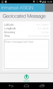
Satellite-ASIGN offers interactive mission-critical visual communications capabilities with geo- and time-tagged photos, where users first send a small preview of a photo, that can be assessed for operational relevance. If and as needed, selected content can later be interactively fetched from the original photos contained within the App.
Satelit-ASIGN ialah versi percubaan UN-ASIGN untuk crowdsourcing rujukan geo-gambar, bentuk teks dan keperluan bencana melalui komunikasi satelit. Tujuannya adalah untuk berkongsi data secara percuma dengan masyarakat antarabangsa kemanusiaan pengurusan bencana, Bangsa-Bangsa Bersatu, Perlindungan Awam.
Dengan menggunakan aplikasi ini, kos komunikasi melalui satelit tidak perlu dilindungi oleh pengguna App. hak-hak umum untuk gambar-gambar milik pengguna, tetapi Inmarsat ini telah diberi hak untuk berkongsi dengan pengguna dan organisasi yang berkaitan dengan sebab ini. Secara khusus pemerhatian akan ditawarkan kepada PBB, untuk diintegrasikan ke dalam peta satelit streaming.
Satelit-ASIGN menawarkan keupayaan komunikasi visual misi kritikal interaktif dengan gambar geo dan masa-tagged, di mana pengguna pertama menghantar pratonton kecil foto, yang boleh dinilai untuk kesesuaian operasi. Jika dan apabila diperlukan, kandungan dipilih kemudian boleh menjadi interaktif diambil dari gambar asal yang terkandung dalam aplikasi ini.
Satellite-ASIGN - Versi 1.2.6
(10-06-2023)Satellite-ASIGN - Maklumat APK
Versi APK: 1.2.6Pakej: ansur.asign.inmarsatVersi Terkini Satellite-ASIGN
Versi lain


Aplikasi dalam kategori sama
 4.484.314.274.334.24


